
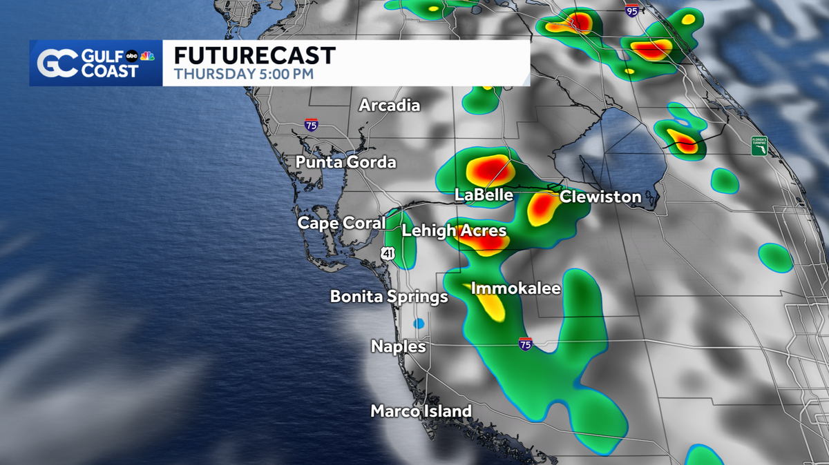
Scattered inland storms for Southwest Florida Thursday
A few coastal showers and storms will be possible throughout the morning.
>> 9, 17, 3 THINGS TO KNOW ABOUT THE WEATHER TODAY HERE ALONG THE GULF COAST. OFF TO A NICE START SEEING PLENTY OF SUNSHINE OUT THERE RIGHT NOW. WE’LL KEEP IT THAT WAY AS WE GO THROUGH THE REMAINDER OF THE MORNING INTO THE EARLY AFTERNOON, AT WHICH POINT WE’LL START TO SEE SOME DOWNPOURS AND STORMS DEVELOPING OUT THERE. ALL THOSE SORT OF LIKE YESTERDAY. I THINK THE BULK OF THE STORMS WE SEE TODAY WILL MAINLY STICK TO OUR INLAND AREAS EAST OF I-75 FOR GLADES, HENDRY INTO YOUR CALL, YOUR PARTICULAR AND THERE WON’T BE MUCH RAIN CLOSER TO THE COAST. THAT THERE’S THAT THE CHANGE OF THE NEXT COUPLE OF DAYS IN PARTICULAR, IT DOES LOOK LIKE WE’RE GOING TO SETTLE BACK INTO A FAIRLY STORMY WEATHER PATTERN. BY THE TIME WE GET TO LABOR DAY AND SUNDAY FOR THAT MATTER. GULF COAST LIVE RADAR, START HERE. SHOWING YOU DRY CONDITIONS. NO RAIN TO TRACK FOR YOU RIGHT NOW. THAT’S THE WAY THINGS WILL STAY LIKE I SAID FOR THE NEXT COUPLE OF HOURS WITH RAIN CHANCES PICKING UP AND PEAKING BETWEEN ABOUT 3 O’CLOCK,BOUT 7 O’CLOCK. AND THEN WE DRY THINGS OUT AS WE GO INTO THE OVERNIGHT. BUT IT’S A SORT OF AN EQUAL OPPORTUNITY, RAIN CHANCES GOING TO BE DRIVEN BY THE SEABREEZE. THE RAIN ISN’T THAT SEA BREEZE GOING TO MARCH FAIRLY FAR INLAND AND TAKE THE RAIN INLAND WITH IT BY 10, 30 ON OUR MODEL HERE. WE’RE ALREADY SEEING THAT SEA BREEZE STARTING TO BUILD IN ACROSS 41 75 BY 12 NOON AT MARCHES ACROSS THE INTERSTATE. THERE COULD BE A FEW POCKETS OF RAIN RIGHT ALONG. 41 TO 75 FROM ABOUT NOON TILL 2 O’CLOCK AS THAT SEA BREEZE IS MARCHING INLAND. BUT IT’S ONCE WE GET TO 3, 4, AND 5 O’CLOCK, THEY REALLY START TO SEE THOSE RAIN CHANCES PICK UP AND NOWHERE MODEL TS THE BULK OF THE RAIN DEEP INLAND COLLIER COUNTY, WHERE SOME HEAVY STORMS WILL BE POSSIBLE. WE’LL BE TRACKING THOSE STORMS AGAIN, JUST ABOUT ALL OF IT INLAND AS WE GO PAST 5 6 O’CLOCK KNOWT THIS POINT, WE’RE SEEING SOME HEAVY RAIN BY LABELLE CLEWISTON OUT ALONG THE ALLEY. NOTHING GOING WEST OF THE INTERSTATE. I THINK THAT TREND HOLDS WITH ALL OF THAT RAIN FADING AWAY TO THE EAST AS WE HEAD INTO THE EVENING, WE DRY THINGS OUT BY MIDNIGHT ACROSS THE BOARD. SO HIS RAIN CHANCES TODAY, SPOTS LIKE LABELLE. MEANWHILE, WORK BACK TOWARD THE COAST, NAPLES I THINK WE MAINLY KEEP IT DRY. TEMPERATURE WISE BY THE COAST. WITH THAT ONSHORE WIND WILL LEVEL OFF AT 90 IN NAPLES. 92 FOR CAPE. GET TO 95 THIS AFTERNOON BEFORE THE STORMS GET GOING INTO LABELLE. NOW LOTS OF COLOR ON THIS MAP. THIS IS SHOW YOU THE MOISTURE CONTENT IN THE ATMOSPHERE, KNOW LITTLE POCKET OF DRIER AIR HAS MOVED ITS WAY INTO NORTHERN FLORIDA. UNFORTUNATELY, NOT WORKING THIS FAR SOUTH. THIS TIME OF YEAR FRONTS CAN MAKE IT THIS FAR SOUTH. THIS EARLY IN THE GAME THAT FRONT SORT OF WASH ITSELF OUT. BUT A NEW FRONT IS GOING TO SET UP IN ITS WAKE OVER NORTHERN FLORIDA AS WE GO INTO THE WEEKEND TO THESE COLORS HERE, THIS TROPICAL MOISTURE THAT WORKS BACK IN HERE. YOU PUT THIS NEXT FRONT IN TO PLAY SUNDAY INTO NDAY. IT’S GOING TO LEAVE US WITH A FAIRLY STORMY SETUP. I THINK ESPECIALLY BY SUNDAY AND MONDAY. TAKE A LOOK AT YOUR GULF COAST. 7 DAY FORECAST AND WE KEEP THE RAIN CHANCES AROUND 40% TODAY. TOMORROW. I THINK SATURDAY TO, YOU KNOW, AS YOU MAKE YOUR OUTDOOR PLANS FOR THE HOLIDAY WEEKEND, I THINK SATURDAY IS THE DRIEST DAY OF THE BUNCH. STILL A FAIRLY HIGH RAIN CHANCE. BUT I THINK THE RAIN MAINLY HOLDS OFF TO THE 2ND HALF OF THE DAY AND THE STORM CHANCES ARE STILL FAVORING INLAND AREAS. BY SUNDAY AND MONDAY WITH THAT FRONT OVER US, WE’RE SETTLING INTO SOMETHING MUCH CLOSER TO WHAT WE SAW LAST WEEKEND WITH WIDESPREAD DOWNPOURS AND STORMS WASHING IN OFF THE GULF IN WAVES. I WOULDN’T QUITE GO SO FAR AS TO SAY, WE’RE LOOKING AT A WASHOUT JUST YET BOTH DAYS, BUT CERTAINLY ON THE TABLE HERE. AND I CAN’T GUARANTEE YOU ANY LONG, DRY STRETCH AT THIS POINT. EITHER DAY EITHER. SO BE SURE YOU’RE CHECKING IN WITH US OVER THE NEXT COUPLE DAYS FROM 10 TO HONE IN ON THAT WEEKEND FORECAST AND WE’LL KEEP THE RAIN CHANCES FAIRLY HIGH INTO NEXT WEE
Scattered inland storms for Southwest Florida Thursday
A few coastal showers and storms will be possible throughout the morning.

Aside from a stray coastal shower or storm, most areas will stay dry this morning as temperatures start out in the 70s.With an onshore wind in place, scattered storms will push inland for the late afternoon and evening.The main threats will be heavy rain and lightning. Storms will wind down after sunset as lows fall into the upper 70s. Friday will feature a similar setup with highs reaching the low 90s and scattered storms building inland for the afternoon. Heading into the holiday weekend, rain chances will ramp up as a south wind drives in more moisture to the region. While no one day will be a washout, the highest coverage will be Sunday and Monday. The tropics are relatively quiet with only one area of interest in the far eastern Atlantic basin as we monitor a tropical wave that will emerge off the west coast of Africa this weekend. The Atlantic hurricane season runs from June 1 through Nov. 30. Follow Gulf Coast News online and on air for Southwest Florida’s Most Accurate weather forecast.Be prepared with the Gulf Coast News 2025 Hurricane GuideLive Interactive RadarCheck out the interactive Gulf Coast Live RadarWatch your Gulf Coast Weather forecasts on TV or onlineHere’s where to find our latest weather forecast videoYou can also watch newscasts live or on demand hereOr download the Gulf Coast News app to stream on your phone or tabletFollow the Gulf Coast Storm Team on social mediaChief Meteorologist Allyson Rae on Facebook and XMeteorologist Caroline Castora on Facebook and XMeteorologist Jim Dickey on Facebook and XMeteorologist Jason Dunning on Facebook and XMeteorologist Rob Duns on Facebook and XMeteorologist Lauren Hope on Facebook and XMeteorologist Raphael Tavernier on Facebook and XDOWNLOAD the free Gulf Coast News app for your latest breaking news and weather alerts. And check out the Very Local Gulf Coast app to stream news, entertainment and original programming on your TV.
Aside from a stray coastal shower or storm, most areas will stay dry this morning as temperatures start out in the 70s.
With an onshore wind in place, scattered storms will push inland for the late afternoon and evening.
The main threats will be heavy rain and lightning. Storms will wind down after sunset as lows fall into the upper 70s.
Friday will feature a similar setup with highs reaching the low 90s and scattered storms building inland for the afternoon.
Heading into the holiday weekend, rain chances will ramp up as a south wind drives in more moisture to the region. While no one day will be a washout, the highest coverage will be Sunday and Monday.
The tropics are relatively quiet with only one area of interest in the far eastern Atlantic basin as we monitor a tropical wave that will emerge off the west coast of Africa this weekend.
The Atlantic hurricane season runs from June 1 through Nov. 30. Follow Gulf Coast News online and on air for Southwest Florida’s Most Accurate weather forecast.
Live Interactive Radar
Watch your Gulf Coast Weather forecasts on TV or online
Follow the Gulf Coast Storm Team on social media
- Chief Meteorologist Allyson Rae on Facebook and X
- Meteorologist Caroline Castora on Facebook and X
- Meteorologist Jim Dickey on Facebook and X
- Meteorologist Jason Dunning on Facebook and X
- Meteorologist Rob Duns on Facebook and X
- Meteorologist Lauren Hope on Facebook and X
- Meteorologist Raphael Tavernier on Facebook and X
DOWNLOAD the free for your latest breaking news and weather alerts. And check out the Very Local Gulf Coast app to stream news, entertainment and original programming on your TV.