
ORLANDO, Fla. – We’re truly on the downhill portion of the 2025 hurricane season, which is excellent news. With time quite literally racing by, it’ll be the end of October before we know it.
It’s around this time of year where things across the tropics start to change a little bit. Like the early months of the season, we’ll start to switch gears and monitor for development closer to home.
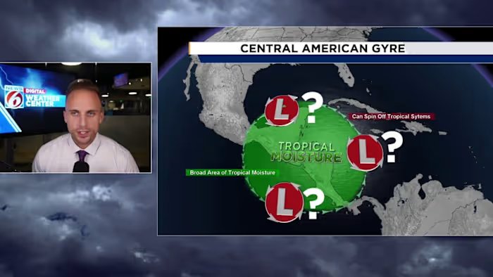
A familiar term you’ve maybe come across in the past comes to mind – the gyre. The Central American Gyre to be exact.
Before we go any further, if you’d like a bit of a crash course on what the gyre is, head on over to this article here where I break it down in greater detail.
I want to quickly dissect what it is I’m seeing for you all, and give you some situational awareness to stew on over the next several days.
We’re about to receive yet another pass from our friend the Madden Julian Oscillation. This is a buzzword for the hurricane season, and pretty much year-round as its a main driver for weather phenomena far beyond just the tropics.
As it comes across, computer models actually suggest this could be one of our strongest passes to date. Meaning we’ll see some pretty favorable conditions set up over the Gulf, the Caribbean, and portions of the Atlantic. At least in terms of what the highest portions of our atmosphere look like.
The MJO promotes lift, and helps add a little extra moisture to the regions throughout the tropics.
Tropical waves and other areas of spin thrive in conditions where they can feed off moisture, warm temps, and lift. So this oscillation is usually a good indicator of when to start watching for things that may try to form.
Because models think this could be a fairly aggressive pass of this lifting mechanism, we’re already seeing an enormous disruption in the flow over Central America. That’s where we watch for the gyre to start up.
Once it does, it’s a matter of time before it tries to hurl a low pressure or two, or even three in several different directions. It is without a doubt one of the trickiest features to forecast, especially if you’re watching for a tropical storm to come out of it.
The Gulf and the Caribbean are already cluttered with showers and storms, increasing the general moisture available for things to take advantage of.
Wind shear hasn’t been all that crazy in recent days either, so as our MJO comes across it could try to spark a named storm or perhaps two before October is all said and done with.
Why am I even bringing this up for everyone? Also, let me quickly answer why it is I encourage you check in with us regarding how this feature tries to establish itself and where we go from there.
The gyre is pretty synonymous with hurling some pretty nasty storms up towards populated areas.
Do you remember Helene and Milton? How about Idalia? Or maybe a bit of a throwback to hurricane Michael of 2018?
All systems brought into existence by none other than the gyre. While there’s never a guarantee, especially from this far out, anything is forming let alone coming to Florida. Typically, it raises eyebrows for us meteorologists whenever it’s in the long-range forecast. It increases our odds of someone receiving a system, and they tend to be on the stronger side the deeper into the hurricane season you go.
The date I’m pinpointing currently is Oct. 12 for things to begin to slowly come together. By Oct. 15 through the 17 is when I believe if a storm were to try to develop, we’ll be on the brink of seeing it do so.
Check back on occasion as I keep you updated through the month of October on all things tropical, especially as I watch model run by model run what the general thinking is just to our south and west.
Copyright 2025 by WKMG ClickOrlando – All rights reserved.