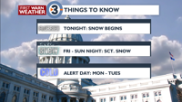
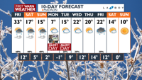
Light snow moves in Thursday afternoon, continues through weekend
1-3″ of light, fluffy snow is possible by weekend end
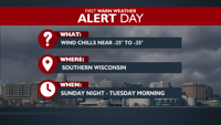
ALERT DAY conditions Sunday – Tuesday due to Arctic blast
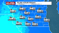
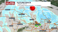
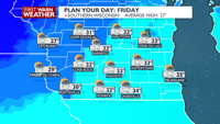
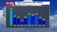
PLANNINGTHE NEXT24HOURS: A low pressure system is going to be moving in overnight and continue to bring southern Wisconsin the chance for light to moderate snow showers. The scattered snow shower activity will continue throughout the day on Friday. Coupled with breezy conditions overnight and Friday, visibilities will be reduced and road conditions may become slick. Temperatures will climb into the low to mid 30s on Friday before cooling down.
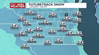
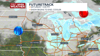
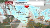
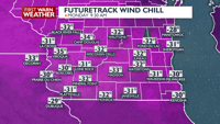
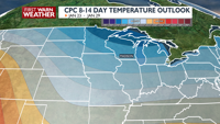
EXTENDEDFORECAST: The snow shower activity will briefly end Saturday before another Clipper brings another round of light snow Sunday. In total, snow accumulations are looking to be widespread 1-3″ with isolated spots of 4″ possible. ALERT DAY conditions take over beginning Sunday through Tuesday as Arctic air sits overhead; wind chill values Sunday, Monday and Tuesday morning will range from -25 to -35. On Monday in particular, temperatures will remain cold with day time highs remaining in the single digits. The cooler than normal average temperature trend looks to stick around through the end of January.
COPYRIGHT 2026 BY CHANNEL 3000. ALL RIGHTS RESERVED.THIS MATERIAL MAY NOT BE PUBLISHED, BROADCAST, REWRITTEN OR REDISTRIBUTED
Humidity: 85%
Feels Like: 10°
Heat Index: 22°
Wind: 12 mph
Wind Chill: 10°
UV Index: 0 Low
Sunrise:07:26:40 AM
Sunset:04:48:41 PM
Dew Point: 18°
Visibility: 10 mi
Today
Mostly cloudy with scattered snow showers, especially in the evening. Some light snow accumulation of a dusting to a half inch possible. Some freezing drizzle is possible overnight.
Wind: SW 10-15 MPH
Tonight
Mostly cloudy with scattered snow showers, especially in the evening. Some light snow accumulation of a dusting to a half inch possible. Some freezing drizzle is possible overnight.
Wind: SW 10-15 MPH
Tomorrow
Mostly cloudy and breezy with scattered snow showers. Some additional light snow accumulation of 1-2” possible.
Wind: W 10-20, with gusts up to 25 MPH
Thu Thursday
23°/24°
Periods of snow. Lows overnight in the low 20s.
Thursday Night
Mostly cloudy with scattered snow showers, especially in the evening. Some light snow accumulation of a dusting to a half inch possible. Some freezing drizzle is possible overnight.
Wind: SW 10-15 MPH
Fri Friday
33°/12°
Snow showers possible. Highs in the mid 30s and lows in the low teens.
Friday Night
Mostly cloudy, breezy, and colder with a chance of snow showers. Wind chills near 0 to -10. Wind: W 15, with gusts up to 25 MPH.
Sat Saturday
17°/5°
Morning snow showers. Highs in the upper teens and lows in the mid single digits.
Saturday Night
Mostly cloudy, breezy, and much colder with a slight chance for flurries. Wind chills near -10. Wind: W 10-15 MPH.
Sun Sunday
15°/-1°
Afternoon snow showers. Highs in the upper teens and lows -5 to -1F.
Sunday Night
Partly cloudy, breezy and bitterly cold with wind chill values between -25 and -35.
Mon Monday
5°/-2°
Times of sun and clouds. Highs in the mid single digits and lows -3 to 1F.
Monday Night
Partly cloudy, breezy, and bitterly cold. Wind chills near -20.
Tue Tuesday
15°/10°
Partly cloudy. Highs in the mid teens and lows in the low teens.
Tuesday Night
Mostly cloudy and cold with a chance for snow showers.
Wed Wednesday
22°/9°
Snow showers early. Highs in the low 20s and lows in the upper single digits.
Wednesday Night
Partly cloudy and cold.
Thu Thursday
21°/14°
Times of sun and clouds. Highs in the low 20s and lows in the low teens.
Thursday Night
Mostly cloudy and cold.
Fri Friday
22°/10°
Cloudy. Highs in the mid 20s and lows in the low teens.
Friday Night
Partly cloudy, breezy and cold.
Sat Saturday
14°/-1°
Mostly cloudy. Highs in the low teens and lows -8 to -4F.