
Central Florida faces high rain and storm chances
ORLANDO, Fla. – Grab that rain gear and keep it close — showers and storms are expected to be a big part of Central Florida’s weekend and beyond.
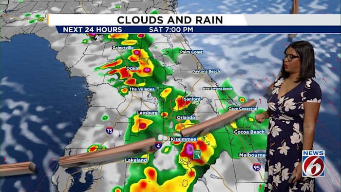
An unsettled weather pattern is settling in with a stationary front lifting north over the area and bringing increased rain chances as the afternoon rolls around.
Rain is forecast to move in mostly during the afternoon, climbing to a 60% chance by 4 p.m. and reaching 70% by 6 p.m. Some storms could pack a punch, with bursts of heavy rain and gusty winds up to 40 miles per hour likely at times.
Highs will reach the lower 90s and it’s expected to stay breezy, especially on the coast. Saturday night should see any lingering showers begin to clear and Sunday morning is forecast to start off dry before rain chances pick up again in the afternoon.
[EXCLUSIVE: Become a News 6 Insider (it’s FREE) | PINIT! Share your photos]
For those wondering about what’s brewing in the tropics, we’re watching Invest 91L. The National Hurricane Center’s latest update notes that while this system is being dampened by Saharan dust, there is still a 30% chance for development over the next two days and a 60% shot over the next week. As of now, there are no tropical threats to Central Florida.
Here’s how the week is shaping up: Saturday will see highs around 92 degrees and a 70% coverage for showers and storms.
Sunday gets a bit hotter at 93 degrees with rain chances at 60%. From Monday onward, Central Florida can expect highs in the upper 80s and frequent rain, as the unsettled pattern lingers through the week.
Need to show us what the weather looks like in your neighborhood? Snap a pic or video and share it with News 6’s PinIt! community by clicking here.
Copyright 2025 by WKMG ClickOrlando – All rights reserved.