
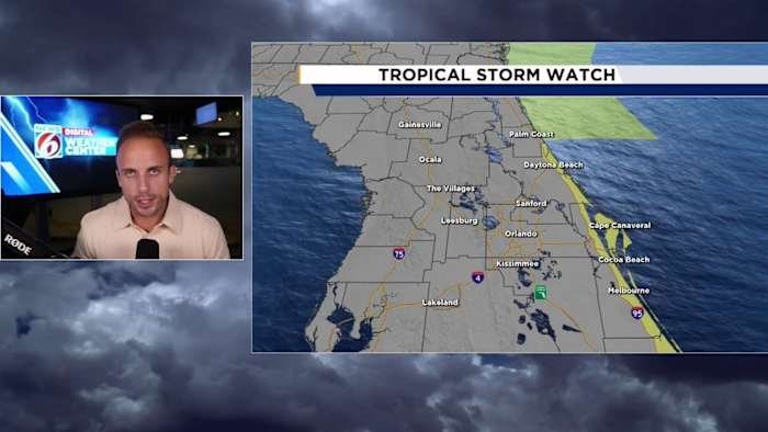
ORLANDO, Fla. – Tropical storm watches now run up and down the length of eastern Central Florida as we await the close shave from Tropical Depression 9, forecast to become a tropical storm named Imelda very soon.
Brevard, Volusia, and Flagler counties are included in these active watches, with an extension both south and north of our viewing area also roped into areas monitoring for potential impacts as we go through the next couple of days.
Before we delve into the details, I want to breakdown the key difference between a watch and a warning.
[EXCLUSIVE: Become a News 6 Insider (it’s FREE) | PINIT! Share your photos]
A watch simply means we have ingredients on the table to see tropical storm conditions come together along our coastline. We have yet to actually put all these ingredients into a bowl to realize these conditions, but we should keep our eyes open as the threat is there.
A warning would indicate we’re expecting the arrival of tropical storm conditions at the forecasted time housed within the bulletin that will come across your phone, on your weather radio, or your television screen.
Right now, the National Hurricane Center and National Weather Service are closely collaborating as to if and when an upgrade to the watch will be issued. As the name implies, we’re all watching.
This is the planning phase for you reading at home right now. If you do need to prepare at a moment’s notice, make sure you have those plans drawn up by tonight. If the warning does drop, that means conditions are coming and you should begin your preparation immediately.
Now, in terms of weather impacts, a lot still hinges on how far left or right future Imelda moves along its track. Right now the NHC keeps it far enough off our coast to where minimal impacts will be felt.
The seas will be rough, rip currents will be deadly, and some beach erosion is likely, but in terms of sustained tropical storm conditions we’re still outside that field for the time being.
There’s an enormous disclaimer I want to add to this – right now computer model guidance is all to the left of where the forecast track is from NHC.
If the storm were to jog any further west of where the center is projected to travel, conditions will deteriorate at a greater extent for folks along the immediate coastline. This is the point where National Weather Service will more often than not push the button on issuing tropical storm warnings.
Right now, Tropical Depression 9 is forecast to also become a hurricane. We’re far enough outside of the sphere of influence to avoid any hurricane conditions in our viewing area thankfully.
For Flagler, Volusia, and Brevard, your Sunday and Monday hinge greatly on how far west this system remains or if it gets yanked more northerly earlier on. Right now as the forecast stands, you could see occasional gusts approaching tropical storm strength when the storm is closest to our east coast, but sustained winds will remain between 15-30 mph.
Wrap-around rainfall could also produce some urban flooding, roadway ponding, and overall hazardous travel conditions especially into your Monday.
Again, if the system does continue more towards the left of the current track, you can double up on some of these effects mentioned above. The chances you see tropical storm force winds on the beach and just inland goes up greatly.
The system is better organized as of tonight as well, so if models begin to head towards a more put together and stronger system our impacts will also be felt further inland.
Now on to the good news! Since the storm is not anticipated to make a landfall in Florida, let alone Central Florida, a lot of us interior counties will hardly notice a tropical system is off our east coast.
It will be pretty breezy outside, and the extra moisture being pushed in from the east will up our rain chances.
Some strong storms are possible, and we cannot rule out the potential of a rogue funnel cloud or two despite being on the generally weaker side of the storm. The “dirty side” as its called will be east of us altogether.
Winds on average will be sustained at about 15-25 mph for just about all of us, with occasional gusts trying to reach beyond 30mph.
I want to emphasize how much the variation we could see in the track dictates what we feel in Central Florida. Our coastline will for sure see some level of increase in winds, rain, and surf.
If we see any additional deviations to the left, closer to the Florida peninsula, we can start to open up the window for harsher conditions to make their way into areas of Seminole, Orange, and Osceola counties, essentially working right to left as the system tries to extend its reach further across our area.
Copyright 2025 by WKMG ClickOrlando – All rights reserved.