Flooding potential lingers in Southwest Florida
Gulf Coast Weather Impact Day: Flooding potential lingers in Southwest Florida
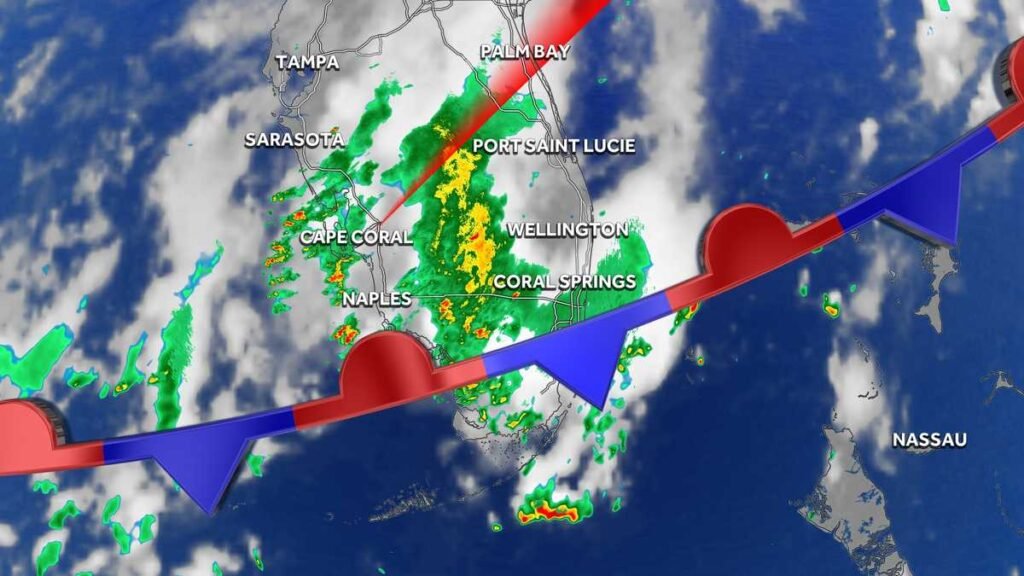
A stalled stationary front will keep the Gulf Coast’s weather unsettled.
JEY’S LIFE WITH THIS STORY IN THE GULF COAST NEWS APP. >> THANKFULLY, THE WEATHER EARLIER TODAY FOR ALL OF THE 9.11 REMEMBRANCE CEREMONIES IN OUR AREA WAS JUST FINE. BUT IT SURE WAS ROCKING AND ROLLING FOR A FEW HOURS HERE EARLIER THIS EVENING. AS YOU CAN SEE, THOUGH, WE ARE ON THE UPSWING NOW AS GULF AST LIVE RADAR SHOWING IMPROVING WEATHER ACROSS THE EASTERN SIDE OF LAKE COUNTY AND ACROSS THE SOUTHERN TIER OF LEE COUNTY WHERE WE’VE HAD AN AWFUL LOT OF RAIN OVER THE COURSE OF THE PAST FEW HOS. IF YOU JUST CONSIDER THE PASTO 12 NE CAMELOT, WE HAVE UPWARDS OF 4 AND A HALF TO NEARLY 5 INCHES OF RAIN CLOSE TO 4 INCHES NEAR THE EAGLE RIDGE EA. JUST MORE THAN 3 AND A HALF NEAR DAN FOREST LAKES. AND THEN CLOSE TO 2 AND A HALF AND ARS NEAR GATEWAY. AND TH EXTENDS ACROSS MOST OF LEHIGH ACRES WHERE RAINFALL TOTALS IN JUST THE PAST 12 HOURS RANGE FROM 2 TO 4 INCHES. BUT YOU CAN SEE WITH WHAT THEY LIVE RADAR LOOKS LIKE RIGHT NOW. FINALLY, THE RAIN HAS STOPPED. WE’RE GOING TO BE WILL HOPEFULLY GET AHEAD OF ANY STANDING WATER THAT’S LEFT OVER FROM THE STORMS EARLIER TONIGHT. THAT’S ALSO THE CASE FOR THAT FLOOD ADVISORY THAT WAS ISSUED SHORTLY. GO FOR NORTH WEST CAPE. THANKFULLY, THE STORMS HAVE PEAKED AND THEY’RE RAPIDLY FALLING APART NOW. BUT KEEP IN MIND, THERE IS QUITE A BIT OF STANDING WATER IN SOME OF THESE NEIGHBORHOODS IN NORTHWEST CAPE. SO THROUGH E TOP OF THE HOUR, JUST MAKE SURE YOU TAKEIT EASY. IF YOU’RE DRIVING ACROSS THE NORTHWEST CORNER OF THE CITY NOW WE DO HA A LOT OF THUNDERSTORMS JUST OFF SHORE OF THE LEE COUNTY BARRIER IANDS. BUT AS YOU GIVE RADAR AND HOS LAPSE, YOU’LL FIND THAT OUTFLOW BOUNDARIES ARE ACTUALLY PULLING THEM AWAY FROM SHORE. SO THERE WILL STILL SEE SOME LEFTOVER RAIN ON THE BARRIER ISLANDS. THE WORST OF THE WEATHER GOING TO STAY OVETHE GULF OVER THE COURSE OF THE NEXT 45 MINUTES UNTIL THOSE STORMS RAIN THEMSELVES OUT. YOU CAN SEE WITHIN HRS LAPSE OVER COLLIER COUNTY. WHAT’S HAPPENING HERE? E PREVLING WINDS WANT TO PUSH THE STORMS THAT WAY. BUT THE OUTFLOW BOUNDARIES WANT TO PULL IN THE OPPOSITE WAY. THE NET RESULT NOW IS THAT THEY’RBASICAY RIPPED THEMSELVES APART SO THAT WE HAVE CLOUD COVER AND SOME LEFTOVER LIGHT RAIN. ALL THIS HEAVY RAIN THAT YOU SEE TO THE SOUTHWEST OF MARCO THAT’S GOING TO KEEP PUSHING OFFSHORE AS WE MOVE TOWARD THE TOP OF THE HOUR AROUND LAKE OKEECHOBEE THEY’RE CERTAINLY WE AREAS OF STEADY RAIN ACROSS THWESTERN SIDE OF LAKE OKEECHOBEE. BUT NOTHING SEVERE. AND AS YOU CAN SEE ACROSS DESOTO IN CHARLOTTE ACTUALLY LOOKS LIKE IN THE PAST FEW MOMENTS, THE NATIONAL WEATHER SERVICE HAS ISSUED ANOTHER FLOOD ADVISORY. THIS ONE HERE, THOUGHLET’S TAKE A LOOK. IS ONE HERE GOES UNTIL 08:30PM, TONIGHT, BUT TAKES UP JUST TO THE NORTH OF ENGLEWOOD. SO THAT’S MORE OF SARASOTA COUNTY. YOU GIVE THE RADAR AND HOURS LAPSE HERE, THOUGH, YOU’LL SEE THE REASON WHY THOSE FLOOD ADVISORIES ARE NECESSARY TONIGHT. AS ONCE THESE THUNDERSTORMS BLOSSOM, THERE’S WASN’T ENOUGH WIND TO PUSH THEM IN ONE DIRECTION OR ANOTHER WHICH ALLOWS THE RAIN TO REALLY STA UP AND SOMETIMES REALLY AGGRESSIVELY LIKE WE HAD INARTS OF LEE COUNTY EARLIER TODAY. SO BIG PICTURE WHEN YOU LOOK AT THE REGIONAL GULF COAST, LIVE RADAR, STILL A LOT GOING ON. BUT HAPPY TO REPORT. NOW WE’RE PAST THE WORST AS THE BRUNT OF THE STORMS HAVE FINALLY PEAKED. NOW, WHY WAS IT SO STORMY TODAY AND YESTERDAY AND THE DAY BEFORE YESTERDAY? WELL, AS YOU KNOW, THERE’S A STALLED STATIONARY FRONT THAT RIGHT NOW IS SITTING JUST TO R SOUTH AND THIS FRONT WILL BE CLOSE ENOUGH THAT ONCE AGAIN TOMORROW THE FORECAST IS GOING TO BE MIGHTY SIMILAR WITH ANOTHER ROUND OF DOWNPOURS AND THUNDERSTORMS THROUGHOUT THE AFTERNOON. BUT EVENTULY THIS FRONT IS GOING TO OFFER US A MUCH NICER WEATHER FOR NEXT WEEK. THIS GRAPHIC HERE, THE DARKER THE RED, THE MO TROCAL MOISTURE IS AVAILABLE IN THE ATMOSPHERE D SEE HOW IT HUGS AT FRONT. BUT AS THE FRONT STARTS TO MOVE WARD OUR SOUTH NEXT WEEK, LOOK AT THE AIR MASS THAT REPLACES IT. IT’S ONE THAT IS CONSIDERABLY DRIER AND MUCH MORE DRIER THAN WE EXPECT TO SEE DURING THE MONTH OF SEPTEMBER. SO THE RESULT FOR NEXT WE IS A BIG, BIG CHANGE IN THE WEATHER PATTERN. INSTEAD OF T STORMY WEATHER WE’VE HAD RECENTLY STORM CHANCES DROP BELOW 30%. L OF EARLY NEXT WEEK AND LOWER HUMIDITY SHOULD ACTUALLY ALLOW E NIGHTTIME LOW TEMPERATURES FOR SEVERAL NIGHTS TO DROP ALL THE WAY DOWNNTO THE LOW 70’S. THAT’S INCREDIBLE. FOR THE MONTH OF SEPTEMBER. THANKFULLY AND EVEN BETTER. THERE’S NO HRICANES. INSIDE THE 7 DAY FORECAST. BUT WITH THIS WEEK BNG THE HISTORICAL PEAK OF THE HURRICANE SEASON, WE’VE GOT A BRAND NEW SLATE OF ONCE ON ROB’S RADAR ADDITIONS FO
Gulf Coast Weather Impact Day: Flooding potential lingers in Southwest Florida
A stalled stationary front will keep the Gulf Coast’s weather unsettled.

A stalled stationary front will keep the weather unsettled at times across the Gulf Coast through Friday evening. Locally heavy rain will be the biggest issue for our community. Considering the amount of rain we’ve seen recently, isolated flooding will be possible at times. The front that has been making our weather so stormy of late is expected to get pushed southward by this weekend. This should offer some noticeable changes to the area with drier air surging southward by the end of the weekend. For now, the biggest impacts we’ll notice will be lower humidity at night and lower rain chances during the day. Nighttime lows early next week are expected to be able to fall all the way into the low 70s, and storm chances remain below 30% on Sunday, Monday and Tuesday. The Atlantic hurricane season runs from June 1 through Nov. 30. Follow Gulf Coast News online and on-air for Southwest Florida’s Most Accurate weather forecast.Be prepared with the Gulf Coast News 2025 Hurricane GuideLive Interactive RadarCheck out the interactive Gulf Coast Live RadarWatch your Gulf Coast Weather forecasts on TV or onlineHere’s where to find our latest weather forecast videoYou can also watch newscasts live or on-demand hereOr download the Gulf Coast News app to stream on your phone or tabletFollow the Gulf Coast Storm Team on social mediaChief Meteorologist Allyson Rae on Facebook and XMeteorologist Caroline Castora on Facebook and XMeteorologist Jim Dickey on Facebook and XMeteorologist Jason Dunning on Facebook and XMeteorologist Rob Duns on Facebook and XMeteorologist Lauren Hope on Facebook and XMeteorologist Raphael Tavernier on Facebook and XDOWNLOAD the free Gulf Coast News app for your latest breaking news and weather alerts. And check out the Very Local Gulf Coast app to stream news, entertainment and original programming on your TV.
A stalled stationary front will keep the weather unsettled at times across the Gulf Coast through Friday evening.
Locally heavy rain will be the biggest issue for our community. Considering the amount of rain we’ve seen recently, isolated flooding will be possible at times.
The front that has been making our weather so stormy of late is expected to get pushed southward by this weekend.
This should offer some noticeable changes to the area with drier air surging southward by the end of the weekend.
For now, the biggest impacts we’ll notice will be lower humidity at night and lower rain chances during the day.
Nighttime lows early next week are expected to be able to fall all the way into the low 70s, and storm chances remain below 30% on Sunday, Monday and Tuesday.
The Atlantic hurricane season runs from June 1 through Nov. 30. Follow Gulf Coast News online and on-air for Southwest Florida’s Most Accurate weather forecast.
Live Interactive Radar
Watch your Gulf Coast Weather forecasts on TV or online
Follow the Gulf Coast Storm Team on social media
- Chief Meteorologist Allyson Rae on Facebook and X
- Meteorologist Caroline Castora on Facebook and X
- Meteorologist Jim Dickey on Facebook and X
- Meteorologist Jason Dunning on Facebook and X
- Meteorologist Rob Duns on Facebook and X
- Meteorologist Lauren Hope on Facebook and X
- Meteorologist Raphael Tavernier on Facebook and X
DOWNLOAD the free for your latest breaking news and weather alerts. And check out the Very Local Gulf Coast app to stream news, entertainment and original programming on your TV.