- NEXT 12 HOURS: Cold with increasing clouds late
- SHORT TERM: Light snow & snow showers
- LONG TERM: Winter chill continues; snow late week
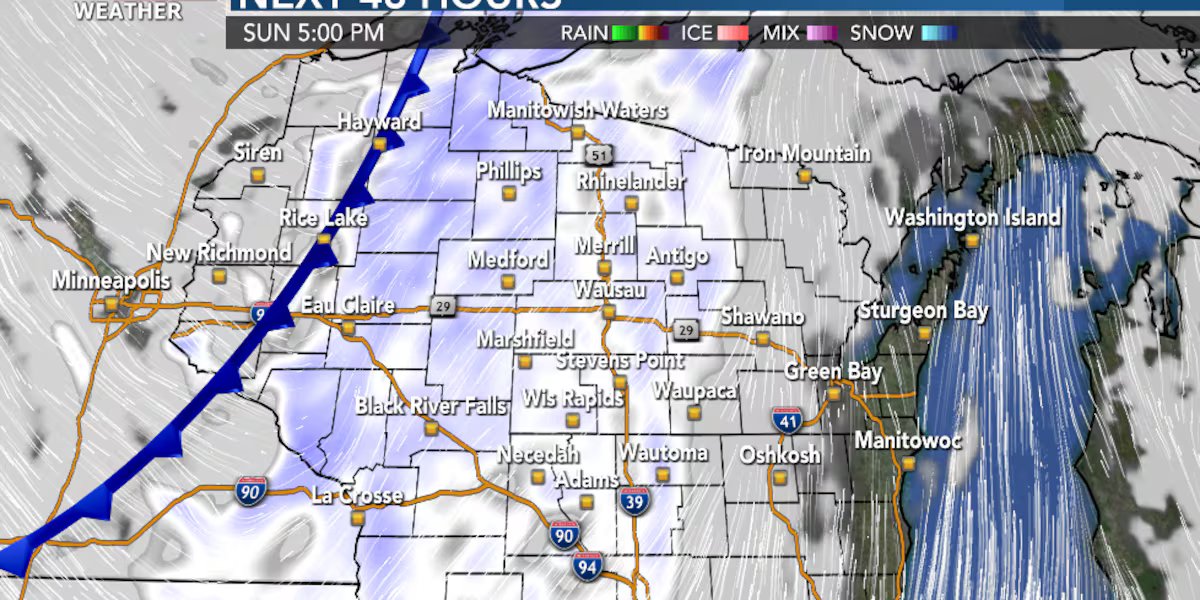
WAUSAU, Wis. (WSAW) – A First Alert for Sunday as a clipper system will produce some snow, leading to slick travel on the roads. The next weather maker impacts the region late week with a risk of snow or snow showers, followed by a blast of colder air.
Have a school, business or church closing, cancellation or delay to report? Click here to register for our closing system.

Clear Saturday evening with increasing clouds overnight. Cold with lows in the single digits above zero.

What’s coming up
Times of light snow and snow showers on Sunday, from late morning into the evening. Roads are expected to range from slippery to snow-covered Sunday afternoon into Sunday night. Accumulations of a coating to around 1″ are forecast for most of the region, with somewhat higher amounts possible west of Highway 13 of 1-2″. Highs on Sunday in the low 20s.

Groundhog Day is on Monday. The odds favor cloudy conditions in Sun Prairie when Jimmy makes his appearance. That would, based on folklore, mean an early spring could be ahead. No less, the weather models are still pointing to much more winter to go. Clouds will break for some sun on Monday with highs in the low to mid 20s.

Looking ahead
Mostly sunny and chilly Tuesday with highs in the upper 10s. A fair amount of sun Wednesday with highs in the low 20s. The next weather maker arrives later Thursday with an opportunity for snow or snow showers into Thursday night. Scattered snow showers and breezy on Friday. Highs in the mid 20s on Thursday for National Weather Person Day, while dropping temperatures on Friday from the upper 20s in the morning to the 10s for the afternoon. Colder on Saturday with a good amount of sun. Highs close to 10°.


Click here to download the WSAW News app or our WSAW First Alert weather app.
Click here to download the WSAW news app or WSAW First Alert weather app.
Click here to submit a news tip or story idea.
Copyright 2026 WSAW. All rights reserved.