Dangerous heat expected in Central Florida as feels-like temps reach triple digits | Impact Weather
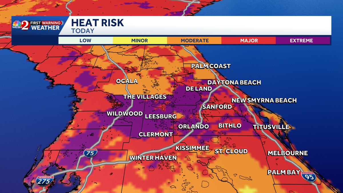
The first warning meteorologist Victoria Wynski, and we need to talk about the forecast today. *** lot of events happening throughout Central Florida. People planning to attend really need to be prepared. It is going to be *** hot one out there, Alan, and you know what, for this time of year we could feel like the triple digits, but when it feels closer to 105 or 110, that’s where the heat risk really becomes *** concern and it’s *** lot less common here across Central Florida. The heat risk in. Purple, that’s extreme. We normally don’t see that around the Sunshine State. And as we do head over the next couple days, today and tomorrow is going to be your most significant heat risk as we head deeper into next week. We’re still going to be elevated across Central Florida and still feeling like the upper 90s and the lower triple digits, but the impact weather is in place for the heat. Advisory that we have through today and even into tomorrow as we head into your Monday, we will be at around 95-50% rain coverage and through the rest of next week will remain rather stable, still 3 degrees above our average for this time of year, but we are still near record temperatures as we head throughout today. So the record set back in 1989 was 98 degrees for Orlando. We’re forecasted at 97, so quite close to the daily high temperature record by tomorrow, looking at 96 degrees, and the record is 99. As we take *** look at the setup for this weekend, we have much more rain across the Gulf, and as we do head into tomorrow, we are going to have *** more moderate rain coverage, but still *** little bit less than we normally see, and it’s going to be through the later half of the day. As we take *** look at your live radar, we are mostly clear. Not many clouds out this morning. And as we take *** live look outside, we have beautiful conditions. *** beautiful sunrise is also upon us. We have plenty of dust coming in, uh, from the tropics, and that is going to create some beautiful visuals for us and also help us with our tropical activity, keeping it quite low. 78 degrees right now in Sanford. And Orlando’s coming in at 75, looking at 78 towards the land and Daytona at 76 degrees, but we’re looking at upper 90s through our peak heating hours. It’s going to be 98 in Bithelo, 95 in Titusville, and 97 towards Orlando trying to find ways to cool down. Here’s *** beach and boating forecast. We’re looking at *** moderate rip current risk and of course the waters are quite warm, so maybe you want to opt for. *** colder pool as we head throughout this afternoon. You’re going to be pretty good for the first couple hours of the day and then we’ll have some showers and storms beginning to pop, quite isolated to start. More activity is forecasted north and west, but as we head through around dinner time, 56 o’clock, we could see more activity, especially towards the land, parts of Marion County into western Flagler County and potentially *** little further west towards Leesburg and Claremont. On that will then clear out as we head towards the evening hours as we track the tropics. No activity expected in the next 7 days as we have plenty of Saharan dust. And if you take *** look at your certified most accurate 7 day forecast across the Sunshine State, impact weather continues for today and tomorrow during our peak heating hours because of our heat advisory. Still going to be pretty toasty as we head into next week, but the heat risk won’t be as widespread, Alan.
Dangerous heat expected in Central Florida as feels-like temps reach triple digits | Impact Weather
Updated: 7:19 AM EDT Jul 11, 2026
The First Warning Weather Team is tracking Impact Weather Saturday across Central Florida because of dangerous heat, with feels-like temperatures reaching the triple digits.Heat advisories issued A Heat Advisory is in effect for the region from 11 a.m. to 7 p.m., with temperatures expected to climb into the upper 90s and heat index values approaching 110 degrees. If you must be outside, you’re encouraged to drink plenty of water and take frequent breaks in the shade.Meanwhile, Saturday will be less stormy than what Central Florida is used to this time of year, but a few storms could develop around dinner time, mainly north and west of Orlando.Tracking the TropicsThe tropics remain quiet, with the National Hurricane Center not tracking any tropical activity over the next seven days.First Warning WeatherStay with WESH 2 online and on-air for the most accurate Central Florida weather forecast.RadarSevere Weather AlertsDownload the WESH 2 News app to get the most up-to-date weather alerts.The First Warning Weather team includes First Warning Chief Meteorologist Tony Mainolfi, Eric Burris, Marquise Meda, Cam Tran and Victoria Wisniewski.What is Impact Weather?Impact Weather suggests weather conditions could be disruptive or a nuisance for travel and day-to-day activities.What is a Severe Weather Warning Day?A Severe Weather Warning Day suggests weather conditions that could potentially harm life or property. ————————————————DOWNLOAD the free WESH 2 News app for your latest news and alerts on breaking news, weather, sports, entertainment and more on your phone or tablet. And check out the Very Local app to stream news, entertainment and original programming on your TV.
The First Warning Weather Team is tracking Impact Weather Saturday across Central Florida because of dangerous heat, with feels-like temperatures reaching the triple digits.
Heat advisories issued
A Heat Advisory is in effect for the region from 11 a.m. to 7 p.m., with temperatures expected to climb into the upper 90s and heat index values approaching 110 degrees.
If you must be outside, you’re encouraged to drink plenty of water and take frequent breaks in the shade.
Meanwhile, Saturday will be less stormy than what Central Florida is used to this time of year, but a few storms could develop around dinner time, mainly north and west of Orlando.
Tracking the Tropics
The tropics remain quiet, with the National Hurricane Center not tracking any tropical activity over the next seven days.
First Warning Weather
Stay with WESH 2 online and on-air for the most accurate Central Florida weather forecast.
Download the WESH 2 News app to get the most up-to-date weather alerts.
The First Warning Weather team includes First Warning Chief Meteorologist Tony Mainolfi, Eric Burris, Marquise Meda, Cam Tran and Victoria Wisniewski.
What is Impact Weather?
Impact Weather suggests weather conditions could be disruptive or a nuisance for travel and day-to-day activities.
What is a Severe Weather Warning Day?
A Severe Weather Warning Day suggests weather conditions that could potentially harm life or property.
————————————————
DOWNLOAD the free WESH 2 News app for your latest news and alerts on breaking news, weather, sports, entertainment and more on your phone or tablet. And check out the Very Local app to stream news, entertainment and original programming on your TV.