Significant heat, humidity continue across Central Florida
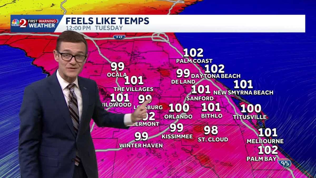
BALLOT MEASURE, ALLEGING IT’S MISLEADING. 517 LET’S TALK ABOUT THAT FORECAST OUT THERE. HOW HOT HAS IT BEEN? RIGHT. SUNDAY STICKY. OH, I WAS LIKE, HOW HOT IS IT OUT HERE? I WAS LIKE, IT FEELS LIKE IT’S 98. THIS RECEPTION I’M GETTING FROM THE BOTH OF YOU IS AS COLD AS IT’S EVER GOING TO BE. IT IS GROSS OUTSIDE. I GET IT RIGHT. WE’RE JUST KIND OF IN A BIT OF A MOMENT HERE. WE’RE HAVING A MOMENT. IT WILL BREAK DOWN EVENTUALLY. WE’LL GET BACK TO EARLY SUMMER WEATHER, BUT FOR NOW, YEAH, THAT SIGNIFICANT HEAT HUMIDITY COMBINATION INCREASES THROUGH THE WEEK UNTIL RAIN COVERAGE INCREASES LATER IN THE WEEK. SO THIS IS WHERE WE’RE STUCK. AND I JUST WANT TO SHOW YOU ANECDOTALLY HERE, 10:00 IN THE MORNING ALREADY FEELS LIKE 97 IN CLERMONT. BUT BY NOON ALREADY NOON FEELS LIKE THE TRIPLE DIGITS AROUND TOWN. AND WE’LL KEEP GOING. ONE ZERO, 3104 OR SO AROUND CENTRAL FLORIDA THIS AFTERNOON. AND THEN WE GET EVEN HOTTER. LOOKING AHEAD TO OUR WEDNESDAY THURSDAY, ACTUAL AIR TEMPERATURE GETS TO 95. IN TERMS OF THE FEELS LIKE READINGS WE’RE IN THAT CENTURY MARK READING ALL THE WAY THROUGH SATURDAY 102103104. JUST KIND OF DEPENDING OF COURSE, ON IF YOU GET A LITTLE EXTRA SUNSHINE OR YOUR EXACT NEIGHBORHOOD. BUT THE IDEA IS OUTDOOR WORK NEEDS TO BE WITH EXTREME CAUTION BECAUSE THIS IS A VERY SIGNIFICANT HEAT EVENT. SO THEN WE SAY, ALL RIGHT, WHEN’S MOTHER NATURE GOING TO HELP US OUT? THURSDAY, FRIDAY. THAT RAIN COVERAGE BEGINS TO INCREASE. BUT FOR NOW, IF YOU LIVE FROM ABOUT THE METRO OFF TO THE EAST, YOU’RE AMONG THE LUCKIER ONES TO BE ABLE TO HAVE THAT HIGHER COVERAGE OF RAIN. SO FOR TODAY, LET’S ZERO IN ON THE TIMING. OKAY, HERE’S FUTURECAST. 10:00 ALREADY FEELS LIKE 97. EVERYBODY’S ALREADY READY FOR THE RAIN. BY 1:00 WE START TO DEVELOP SOME SHOWERS OUT WEST OF TOWN. WE’LL GET OUR BEST CHANCE, I THINK THROUGH THE METRO. THERE’S 3 P.M. THIS IS A BRAND NEW RUN OF FUTURECAST. CHANGED EVEN SINCE THE LAST TIME I SAW YOU. NOTICE IT PUSHES EVERYTHING OVER TOWARD THE BEACHES. BY 5:00, AND A FEW LINGERING SPRINKLES AROUND DINNERTIME, SO IT LOOKS LIKE IT’S AN EARLIER START TO THE RAIN, BUT A BIT OF A SUBDUED COVERAGE. THE MODELS HAVE BEEN TRENDING SLIGHTLY DRIER FOR TODAY OUTSIDE TOURIST DISTRICT, LOOKING A LITTLE HAZY, WHICH MAKES SENSE. HOT, HAZY, HUMID. KIND OF FORECAST 77 RIGHT NOW IN ORLANDO. IT’S 78 IN THE VILLAGES, 76 DAYTONA BEACH AND 76 DEGREES IN MELBOURNE. NOTHING TO SEE ON OUR FIRST WARNING LIVE RADAR. IT’S JUST ALL ABOUT THAT HEAT, THAT SOUTHWEST WIND IS ALWAYS A HOT WIND FOR US HERE IN CENTRAL FLORIDA TODAY, 510 MILES AN HOUR, GUSTING TO 20, ABOUT 94 IN THE CITY, 93 IN WILDWOOD, 92 IN OCALA, MID 90S. BACK OVER EVEN TO THE SHORELINE. AND IF YOU’RE HEADING OVER TO THE BEACH TODAY, WATER TEMPERATURES IN THE LOWER 80S, IT’S GOING TO FEEL GREAT BECAUSE WE GOT TO GET COOL. YEAH, 94, 95 DEGREES, 40, 50, 60% COVERAGE OF RAIN FOR THURSDAY, FRIDAY. NOTICE ON THAT COASTAL SEVEN DAY FORECAST, YOUR RAIN CHANCES ARE A BIT ELEVATED BECAUSE ALL THE RAIN WANTS TO EVENTUALLY MOVE YOUR DIRECTION. SO THE GOOD NEWS IS HAVE THE UMBRELLA BECAUSE IT’S GOING TO RAIN ON YOU. THE
Significant heat, humidity continue across Central Florida
Updated: 5:58 AM EDT Jun 16, 2026
It’s another humid start to the day, with temperatures expected to reach the mid-90s and rain coverage increasing to 60%. This steamy and stormy weather pattern is expected to persist much of the week ahead.Tracking the TropicsMedium 60% chance something forms off the coast of Texas and Louisiana on Tuesday or Wednesday as energy moves off the coast. The window is narrow, but a quick system could form in the Gulf; it is of no threat to Florida.First Warning Weather Stay with WESH 2 online and on-air for the most accurate Central Florida weather forecast.RadarSevere Weather AlertsDownload the WESH 2 News app to get the most up-to-date weather alerts. The First Warning Weather team includes First Warning Chief Meteorologist Tony Mainolfi, Eric Burris, Marquise Meda, Cam Tran and Victoria Wisniewski.
It’s another humid start to the day, with temperatures expected to reach the mid-90s and rain coverage increasing to 60%.
This steamy and stormy weather pattern is expected to persist much of the week ahead.
Tracking the Tropics
Medium 60% chance something forms off the coast of Texas and Louisiana on Tuesday or Wednesday as energy moves off the coast.
The window is narrow, but a quick system could form in the Gulf; it is of no threat to Florida.
First Warning Weather
Stay with WESH 2 online and on-air for the most accurate Central Florida weather forecast.
Download the WESH 2 News app to get the most up-to-date weather alerts.
The First Warning Weather team includes First Warning Chief Meteorologist Tony Mainolfi, Eric Burris, Marquise Meda, Cam Tran and Victoria Wisniewski.