Winter weather returns with lake effect snow and frigid temperatures!
A WINTER STORM WARNING will be in effect from 7 a.m. on Wednesday until 1 p.m. Thursday for Berrien and Cass Counties in Michigan and LaPorte, Marshall, Starke and St. Joseph Counties in Indiana.
A WINTER WEATHER ADVISORY will be in effect from 7 a.m. on Wednesday until 1 p.m. on Thursday for Elkhart, Kosciusko, Fulton, and Pulaski Counties in Indiana.
A heavy band of lake effect snow has developed and will swing across the area this evening.
Forecast models have shown a westerly trend in where the bullseye for heaviest accumulation could be.

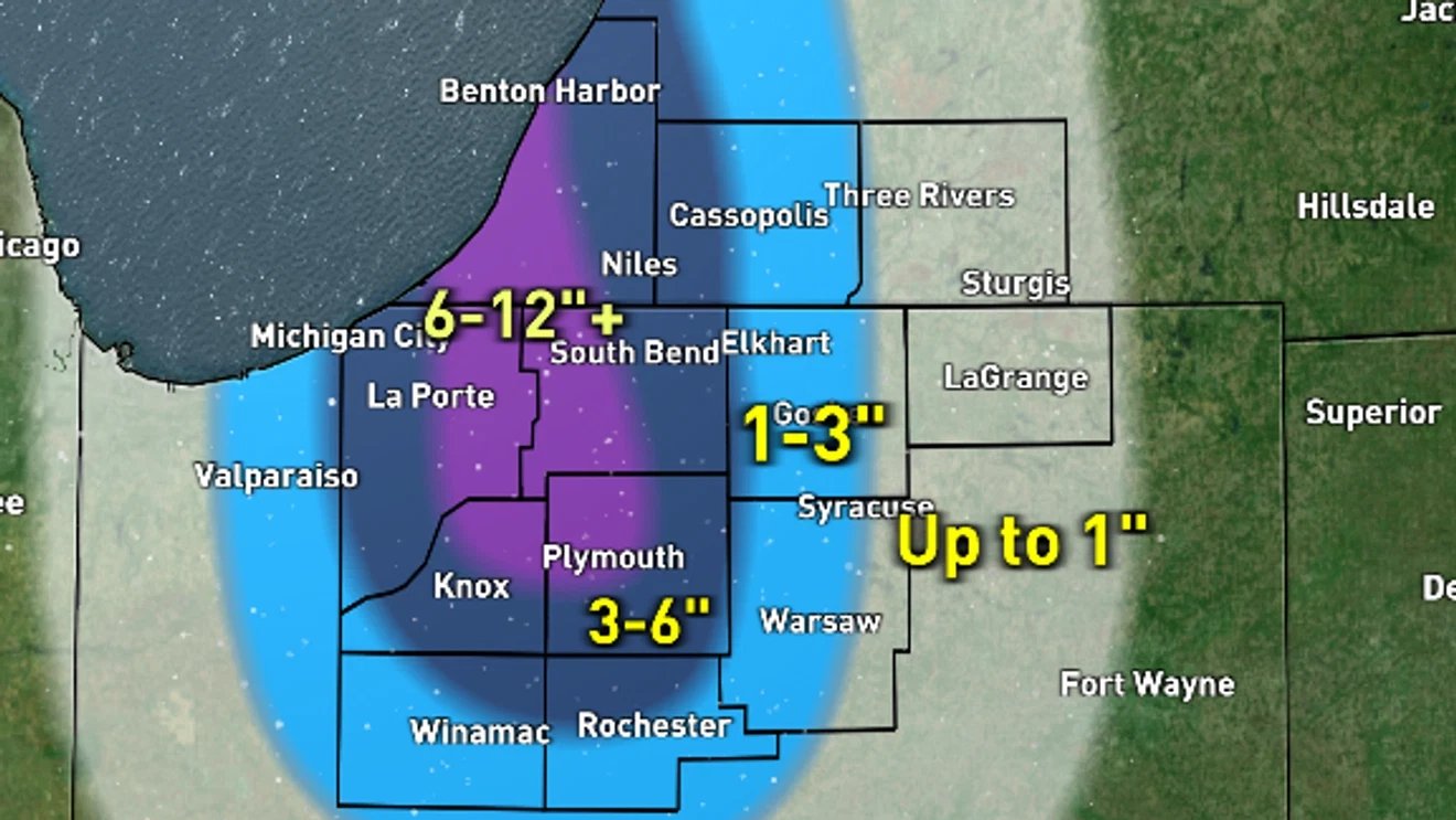
A heavy band of lake effect snow will swing across the area Wednesday night, likely favoring our more western communities (WSBT 22)
Data is now favoring Berrien, LaPorte, St. Joseph (IN), Knox, Starke and Marshall for the potential of heavy snow totals 6-12″ or more.

Heavy snow accumulations possible for part of our area from heavy lake effect Wednesday into Thursday (WSBT 22)
Areas farther east likely will not see as much accumulation, but travel can still be impacted.

Travel Wednesday evening through Thursday morning could be tricky due to heavy lake effect snow and reduced visibility (WSBT 22)
Winds will be gusty Wednesday evening and overnight. Wind gusts could reach around 30 mph or stronger. This could blow snow around and drive down visibility Wednesday evening through Thursday morning.
Travel Wednesday evening through Thursday morning could be tricky due to heavy lake effect snow and reduced visibility (WSBT 22)
Lake effect snow will continue into the morning Thursday, eventually tapering off by the afternoon.

Lake effect snow will start to taper off Thursday afternoon (WSBT 22)
Thursday will be colder with highs in the low to mid 20s, but still feeling like the single digits thanks to the wind.
With the wind, temperatures will feel like the single digits even into Thursday.
We will get a short break from snow Thursday afternoon, but a quick system will arrive Thursday night into early Friday. This will give us another 1-2″ for everyone.
BE THE FIRST TO COMMENT
Heading into the weekend, there continues to be additional chances of lake effect snow and accumulating snow. Even colder air shows up for next week.